")
Goldplay Exploration Ltd. (TSXV:GPLY) (the “Company” or “Goldplay”) is pleased to announce initial results of four drill holes of the Company’s first phase of its core drilling program, at its 100%-owned El Habal Project, Sinaloa, Mexico. The program has successfully identified near-surface continuity of gold mineralization. Four drill holes were completed at El Habal, totaling 1045.85 meters. Highlights include:
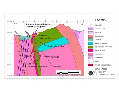
- 77.5 m @ 0.43 g/t Au in drill hole 18 EH-2
- Including 9.45m @ 2.05 g/t Au
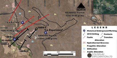
- 15.4 m @ 1.35 g/t Au in drill hole 18 EH-1.
")
")
All drill intercepts are outlined in Table 1 (below).
Goldplay President and CEO Marcio Fonseca commented, “Goldplay’s objective is to define the geometry and controls of mineralization at El Habal within the 6 km-long prospective corridor, expanding gold mineralization both along strike and down dip. We are pleased with the progress the Company has made towards advancing this goal. The next step will be a follow up drill program”.
The drill intercepts have revealed wide gold mineralization hosted in a series of altered rhyolites, andesites and intrusives. The mineralization represents a high-level gold system hosted in a volcanic sequence with intrusive (granitoids) and related hydrothermal fluids. The alteration zone on surface combined with a series of mineralized breccias, structures/fault zones suggests placement at high-level, low-pressure brittle regime with hydrothermal fluids occurring within multiple regional fault structures present in the 6km-long mineralized corridor.
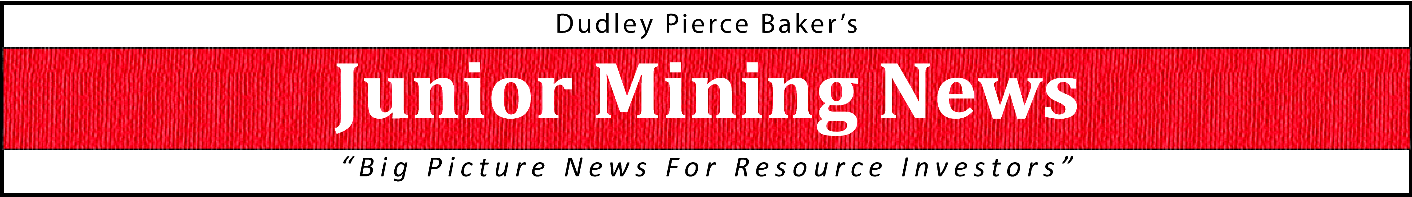
The location of drill holes 18EH -1 to 18 EH-4 are shown in the figure below, in relation to recently announced trench results (see news release June 5, 2018) and historical old workings.
El Habal Drill Results Summary
The following table summarizes selected intercepts from four drill holes. Widths are considered near true thickness and individual composites are disclosed as uncapped. Drilling tested gold mineralization up to 100 meters below the surface, demonstrating mineralization continuity from the (previously reported) surface trenching results.
Table 1: Drill Results Summary
| Hole ID | From (m) | To(m) | Interval (m) | Gold (g/t) |
| 18-EH1 | 25 | 40.4 | 15.4 | 1.35 |
| 18-EH2 | 0.0 | 77.5 | 77.5 | 0.43 |
| Including | 67.6 | 77.5 | 9.45 | 2.05 |
| 18-EH3 | No significant values | |||
| 18-EH4 | Not Completed due to technical problems – Due to presence of old workings | |||
Geological Background El Habal Project
The El Habal Project is located in the Rosario Mining District, a historical mining district with approximately 250 years of mining history. The Rosario Mining District has multiple mineral occurrences and mines in operation, such as the Rosario Mine, Trinidad Mine (Marlin Gold Mining Ltd), Plomosas Silver Project (First Majestic Silver Corp). The El Habal Project is near the historical Au-Ag Rosario Mine (“Rosario Mine”). The El Habal Project has many key features representing highly prospective regional structures with evidence of hosting multi-phase intrusive events in a volcanic sequence. El Habal contains multiple mineral occurrences and a rich history of shallow artisanal mining operations.
Mapping and recent drilling suggest the gold mineralization at El Habal was emplaced at a high crustal level and is associated with intrusion-related hydrothermal fluids. Stockwork systems mapped on surface, alteration zones, drill-confirmed mineralized breccias, structures and regional fault zones suggest a multiphase intrusive related system. The wide structural zones such as mapped along strike from 18-EH2 and 18-EH1, represent a target and model to support exploration opportunities along strike and down dip.
El Habal Project Ongoing Exploration
A representation of cross sections hosting an intense stockwork system, brecciation and multiphase intrusive units has been defined within the wider lower-grade intercepts (drill holes 18-EH2), as illustrated in Figures 4 below. Higher grade gold results represent zones of more intensive brecciation and silicification. Drill results from these 2 holes have confirmed previously reported trench results, providing valuable information to support ongoing exploration. Further drilling will be required to determine continuity of the wide intersections and high grades reported in this news release. The Company is also expanding surface sampling along the 6 km prospective corridor in order to identify similar mineralization occurrences.
QA/QC Protocols
Thorough QA/QC protocols are followed at all sampling programs and assays completed by the Company. Goldplay’s management includes routine duplicates, blanks and standard samples in assays lots for all surface samples and drill hole samples. The samples are submitted directly to SGS Laboratory in Durango, Mexico for preparation and analysis. Analysis are performed using fire assay method with atomic absorption spectrometry finish. Gold results over 5 g/t are routinely rerun using gravimetric …read more
From:: Investing News Network