As a general rule, the most successful man in life is the man who has the best information
Geology
“Geologists are scrambling to understand what created the phenomenal concentrations of gold at the Valley of the Kings discovery of Pretium. Recent drill results include 0.5 meters that carried 41,582 grams per tonne gold (1.6 feet at 1,213 ounces per ton of gold). Another hole hit 2,393 g/t gold 1,605 g/t silver over 10.7 meters (70 ounces gold and 47 ounces of silver per ton over 35 feet). Numerous intersections have exceeded 1,000 g/t, grades rarely seen in gold deposits.
The broad picture, in simplest terms, is that most of British Columbia is made up of blocks of crustal material (terranes) that have been accreted to the coast over a period of hundreds of millions of years. Those terranes include a wide variety of rock types, including metal-rich material derived from the depths of the crust.
Most metal deposits are derived from hydrothermal systems. That is, superheated water, circulating kilometers deep in the crust, gathers metal atoms and then deposits them in particular zones, creating concentrations of metals. Typically, such a system would remain active for hundreds of thousands of years to as much as perhaps a couple of million years. For reasons not yet well understood, the hydrothermal processes in the Golden Triangle were active for much longer, in some areas for perhaps 10 million years. Few areas on the planet have seen such long-lived geological conditions.
That long period of stable mineralizing systems played an important role in creating the high concentrations of metals at Eskay Creek and Valley of the Kings. It is also the reason for the very large and well mineralized systems at Red Chris, KSM, Galore and other porphyry deposits in the region.” Kitco.com, British Columbia’s Golden Triangle
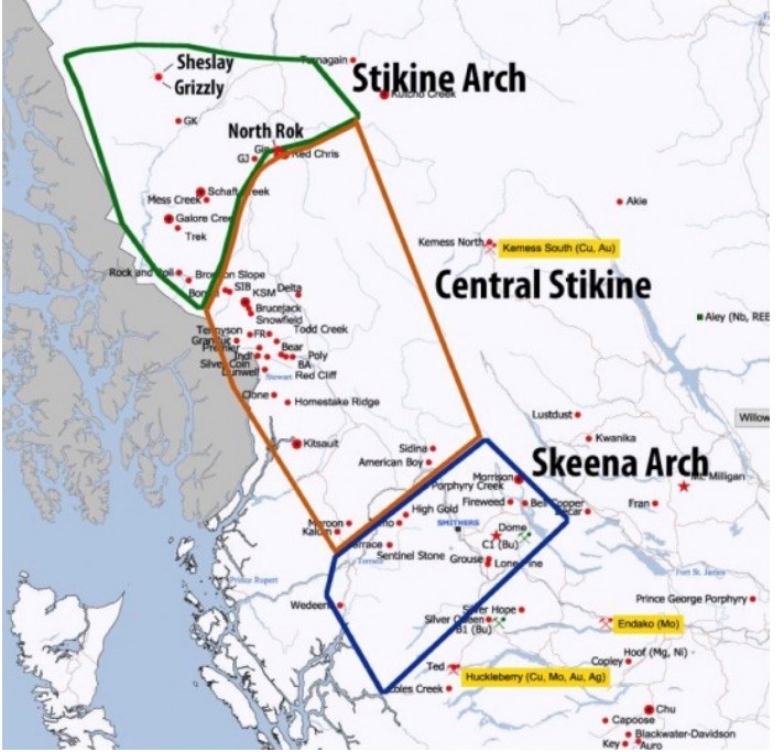
About 150 million years ago during the Jurassic geological period, an uplift of Jurassic and older rocks cut across central British Columbia and resulted in the separation of the Bowser and Nechako basins. Rocks exposed along the “Skeena Arch” represent a magmatic arc, where over a long period of time, magma rose up from deep in the earth to produce a wide range of mineral deposits including porphyries, precious metal veins, and coal. The Skeena Arch has some of the mostly richly endowed mineral terrain in BC and has been a destination for prospectors and mining companies for the past 125 years.
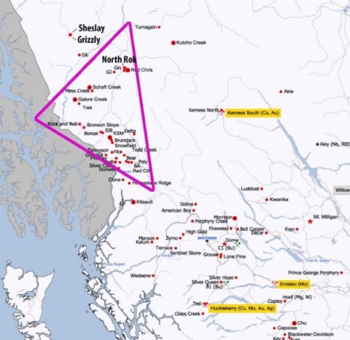
The map below shows the Golden Triangle where a lot of historical exploration and mining has taken place in the last century and a quarter, and where over the past couple of years juniors have rushed in to stake claims as mineral exploration conditions and the gold market have improved.
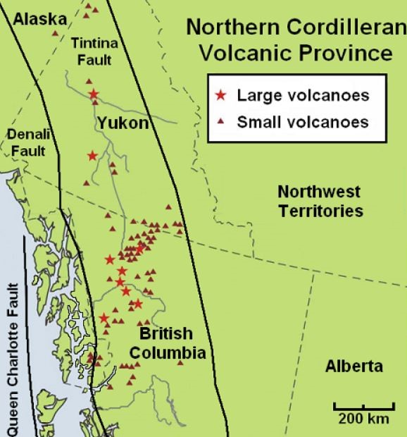
Note the three arches bounding the Golden Triangle in the second map: the Skeena Arch, Central Stikine and Stikine Arch. The Stikine Arch is one of four terranes – or distinct geological structures with different histories – along with Cache Creek, Yukon-Tanana and Cassiar, which form the bedrock of the Northern Cordilleran Volcanic Province, a wide belt of volcanoes that extends all the way from Stewart, BC in the south, through the Alaska Panhandle north to eastern Alaska. According to a presentation by Geoscience BC, “World class gold-rich deposits are associated with the Late Triassic, and Early Jurassic intrusive suites in NW Stikinia.” The non-profit research group also states that bulk tonnage copper/ gold/ silver porphyries (igneous rock consisting of large-grained crystals such as feldspar or quartz) in the Stikinia, and bonanza-grade gold and silver epithermal veins are associated with the early Jurassic period, such as the KSM (Seabridge), Snowfield and Brucejack (Pretium) deposits.
This article will trace the history of the Golden Triangle, explain why the area has become hot again after many years of neglect, and present a few junior resource company successes from the Triangle last year. Lastly, we’ll roll out a watchlist of juniors that are on our radar as potentially hitting the next big discovery hole.
A brief history
Just inland from the Alaska Panhandle, the Golden Triangle has been the site of three gold rushes and some of Canada’s greatest mines, including Premier, Snip and Eskay Creek. Other significant and well known deposits located within the Triangle include Brucejack, Galore Creek, Copper Canyon, Schaft Creek, KSM, Granduc, and Red Chris.
Alexander Choquette kicked off the Stikine Gold Rush in 1861 after finding gold at the confluence of the Stikine and Anuk Rivers.
Premier Gold Mine, which started operations at Premier in 1918, returned 200% on the stock market between 1921 and 1923. The Snip Gold Mine produced a million ounces in the 1990s at an eye-popping average grade of 27.5 grams per tonne (g/t), and Eskay Creek was Canada’s highest grade gold mine and the world’s fifth largest silver producer, with production well over 3 million ounces of gold and 160 million ounces of silver, before it closed in 2008.
Porphyry copper-gold deposit Galore Creek, now owned by Novagold and Teck Resources, has 9 billion pounds of copper, 8 million gold ounces and 136 million ounces of silver. Another porphyry, Shaft Creek, a JV between Copper Fox Metals and Teck, contains 5 billion pounds of copper, 5.8 million ounces of gold, 363.5 million pounds of molybdenum and 51.7 million ounces of silver. (2013 feasibility study)
But after decades of productive mining and some big discoveries, the Golden Triangle went dormant. Isolated from major infrastructure, the area was expensive to conduct sampling, surveys and drill programs, and due to its harsh winter climate, was only accessible for half a year. Not much news came out of the Golden Triangle during the 1990s and 2000s. When gold prices weakened, to about $400 an ounce, several mines shut down, unable to make a decent margin against fixed costs.
What changed?
Despite over 130 million ounces of gold, 800 million ounces of silver and 40 billion pounds of copper having …read more
From:: Mining.com